HuntingNut
HuntingNut
   Login or Register
HomeCommunity ForumsPhoto AlbumsRegister


User Info

Welcome Anonymous


Membership:
Latest: IPutMoInYoA
New Today: 0
New Yesterday: 0
Overall: 13131

People Online:
Members: 0
Visitors: 161
BOT: 2
Total: 163
Who Is Where:
 Visitors:
01: Home
02: Forums
03: Forums
04: Home
05: Forums
06: Forums
07: Home
08: Home
09: Forums
10: Forums
11: Forums
12: Forums
13: Forums
14: Photo Albums
15: Home
16: Home
17: Forums
18: Forums
19: Forums
20: Forums
21: Forums
22: Home
23: Forums
24: Forums
25: Forums
26: Forums
27: Home
28: Forums
29: Home
30: Forums
31: Forums
32: Your Account
33: Home
34: Your Account
35: Forums
36: Forums
37: Forums
38: Forums
39: Forums
40: Forums
41: Forums
42: Forums
43: Forums
44: Forums
45: Forums
46: Home
47: Home
48: Forums
49: Forums
50: Forums
51: Forums
52: Home
53: Forums
54: Home
55: Forums
56: Forums
57: Home
58: Forums
59: Forums
60: Forums
61: Your Account
62: Home
63: News
64: Forums
65: Forums
66: Home
67: Forums
68: Forums
69: Forums
70: Forums
71: Forums
72: Forums
73: Photo Albums
74: Forums
75: Forums
76: Your Account
77: Forums
78: Forums
79: Forums
80: Home
81: Home
82: Home
83: Forums
84: Forums
85: Home
86: Forums
87: Forums
88: Home
89: Forums
90: Forums
91: Forums
92: Photo Albums
93: Your Account
94: Home
95: Forums
96: Your Account
97: Forums
98: Forums
99: Forums
100: Photo Albums
101: Forums
102: Forums
103: Forums
104: Forums
105: Home
106: Forums
107: Forums
108: Forums
109: Forums
110: Photo Albums
111: Home
112: Forums
113: Forums
114: Photo Albums
115: Home
116: Your Account
117: Your Account
118: Your Account
119: Photo Albums
120: Forums
121: Forums
122: Forums
123: Forums
124: Forums
125: Forums
126: Forums
127: Forums
128: Forums
129: Forums
130: Forums
131: Forums
132: Forums
133: Forums
134: Forums
135: Forums
136: Forums
137: Forums
138: Forums
139: Forums
140: Forums
141: Home
142: Forums
143: Forums
144: Forums
145: Forums
146: Forums
147: Forums
148: Forums
149: Forums
150: Photo Albums
151: Your Account
152: Forums
153: Forums
154: Forums
155: Forums
156: Forums
157: Forums
158: Forums
159: Home
160: Forums
161: Photo Albums
  BOT:
01: Forums
02: Photo Albums

Staff Online:

No staff members are online!
 

Coppermine Stats
Photo Albums
 Albums: 308
 Pictures: 2452
  · Views: 824013
  · Votes: 1316
  · Comments: 86
 

COMPASSES
Big Game Hunting topics that dont fit other categories
Go to page Previous  1, 2, 3, 4, 5, 6  Next
Post new topic   Reply to topic   Printer Friendly Page    Forum Index » Big Game Hunting

View previous topic :: View next topic  
Author Message
watchmaker
Member
Member


Joined: Jun 29, 2007
Posts: 98
Location: New York

PostPosted: Fri Sep 14, 2007 8:45 am    Post subject: Re: COMPASSES Reply with quote

I have been twice engolfed in FOG so thick that was like pea soup and could not see the trees 12 feet in front of me.

If were not for the compass I will not have known in which direction to walk out.

Watchmaker
Back to top
View user's profile
watchmaker
Member
Member


Joined: Jun 29, 2007
Posts: 98
Location: New York

PostPosted: Fri Sep 14, 2007 8:46 am    Post subject: Re: COMPASSES Reply with quote

MAP COMPASS AND GPS
USING THE UTM GRID

A GPS is a great navigation tool. Among others things it can tell where you are on hearth which was the main concern for earlier navigators of the Spanish and Portuguese navies, until reliable navigation tools such as the sextant were invented.

Land navigation and exploration was also the province of the sextant; it was used in the jungles with an artificial horizon (a separate glass case containing mercury), and the star to drop down was the sun, as the readings were taken during the day as tree canopy made night reading almost impossible.

Today a small gadget called GPS can do the same for us in only a few minutes. The tool can give us our position on a map using Latitude and Longitude, UTM, military grid, or user grid.

It can do this during the day or night, with clouds or storm, best of all the GPS can fit even in a small pocket, the new units are more accurate than ever and can pin point your position with an accuracy of a few feet.
This position can be plot in a topographic map if you have a latitude/longitude ruler or even eyeballed, if the map is provided with a UTM grid or military grid.

Most new topographic maps now are provided with an UTM grid (Universal transverse Mercator) which is based on the metric system. In this system the latitude is measured in meters north or south of the Equator, and the longitude from meters from the center of a zone, of course the names change and the longitude is called Eastings and the latitude Northings.


In our map you can see an X named start and another X named finish. The place marked finish is where we left the quads on the side of the trail to climb up to Blenheim Hill early that morning. The purpose was to check the creek for trout and scout the area adjacent to the top of the hill.

The reading on the GPS for the place where we left the quads, was 4.700.200 meters North (you use the margin of the map scale) and 541,100 meters East from zone 18 (you use the scale in the top of the map). The first two numbers are the Zone and do not count as meters.
As we had spent two days using the GPS on others locations the gadget was getting very low on battery juice, so we decided to navigate by compass and save the batteries to take readings of the position of interesting places only.

By the end of the day and very tired we found ourselves near the unimproved road that lead to the road next to the cemetery. A reading of our position with the GPS using the UTM system indicated that we were 4,700.000 meters north of the Equator and 539,400 meters east of the zone 18, (see how easy is to count meters in the 1,000 squares with the tick’s marks in the margin of the map counting for 100 meters each).
Tracing a line from start to finish and measuring the degrees with the compass (used as a protractor and disregarding the magnetic needle) gave us a direction to go 80 degrees and 1700 meters for distance, (but the GPS already told us that).
The trek was on okay -terrain slopping downhill and we had to be careful with our footing only in the last 350 meters downhill to the quads.

The other option was to take the road going to the one near the cemetery (1300 meters) walk on that road passing by the ruins of the School until the next trail left (1900 meters) and walk uphill about 1,000 meter to the quads, a total of 4,200 meters.

In a heavy forest with no landmarks and not elevation to take triangulations readings with a compass, it is impossible to know where you are, the GPS can give you your exact position day or night and you can plot that position in the map using the Universal Transverse Mercator grid.

You can do that also with the Longitude and Latitude, but you have to prepare your map (with a different grid) and have a latitude and longitude ruler to measure your position. As GPS’s are easily adjusted for the UTM grid, it is the most convenient and easiest to use of all the grids.

In this explanation we have used the three tools to complement each other, the map, GPS and compass, and demonstrated that finding a road at the end of the day, it is not the shortest route for traveling to your destination; it also demonstrated that you don’t have to be glued to your GPS (as I see many people in the woods doing) to get your money worth out of the gadget.
Best wishes
Watchmaker
Back to top
View user's profile
Deleted_User_2665
Super Member
Super Member


Joined: May 06, 2006
Posts: 380

PostPosted: Fri Sep 14, 2007 7:00 pm    Post subject: Re: COMPASSES Reply with quote

watchmaker wrote:
I have been twice engolfed in FOG so thick that was like pea soup and could not see the trees 12 feet in front of me.

If were not for the compass I will not have known in which direction to walk out.

Watchmaker

Yep....

Lottsa reasons to need a compass rather than "horse sense" or whatever it was called.....

Fog as you say, blinding snow storms, monsoonesque rainstorms....all impeed ones ability to navigate by landmarks and instinct.

If GPS doesn't work very well in a thickly timbered canopy...then I can't imagine it fairing better in crappy weather.

A map, compass and the ability to use them really is the smartest route to take......pun there.
Back to top
View user's profile
watchmaker
Member
Member


Joined: Jun 29, 2007
Posts: 98
Location: New York

PostPosted: Sun Sep 30, 2007 7:43 am    Post subject: Re: COMPASSES Reply with quote

AREA, LINE, AND POINT POSITION

In my previous post I marked my point position and the point position of the quads on the map with the help of the GPS and the UTM grid on the map.
That pin point of location is called point position, and should be the goal of every traveler in the wilderness to know about his point position; after all you could be lying down with a broken leg unable to move and in need of rescue.
Line position is when you know that you are on a feature on the map but cannot pin point your exact location, let’s say you know you are somewhere along the river, road, ridge, trail or compass bearing, but you don’t know exactly where.

Area position is when you know you are in a general area on the map; your goal should be to know at all times where you are on the map, and if you can tell your point position the better, you never know when you may need to summons help (over your cell phone or radio) and need to tell them exactly where you are.

Now we are going to try to mark our point position with the help of our compass and map alone, no GPS this time to help us out.
To accomplish this you need a map with an UTM grid. Since 1989 all new maps are printed with the UTM grid. If your map doesn’t have it you can trace it by the ticks’ marks on the edges of map using a yard stick and a pencil.
For compass and map work I recommend you spend a few dollars more and buy one with the adjustable declination scale, I use the Suunto M-5SK (smoke killer) but there are others in the market that have this convenient feature.
That way, when you are taking or plotting readings from the compass the values will be in geographic North and you will not have to be doing mathematics factoring the declination on your calculations.

Also forget about using lensatic or prismatic compasses, its readings are in magnetic and don’t have a base plate that can be used as a protractor like in the Silva system. To use lensatic and prismatic compasses with maps you will also need to carry a protractor to measure the angles and convert the magnetic readings to true North by adding or subtracting the declination, something that you don’t want to do when you are under pressure or confused by cold or stress.

The Silva system is a compass, protractor, measuring device, ruler, straight- edge and even (as in the case of the M-5SK and others) a magnifying glass.
If you rather use the compass that you already have, and it is a base plate compass or one with transparent base, you can mark your declination with a piece of white label like the one in this picture.


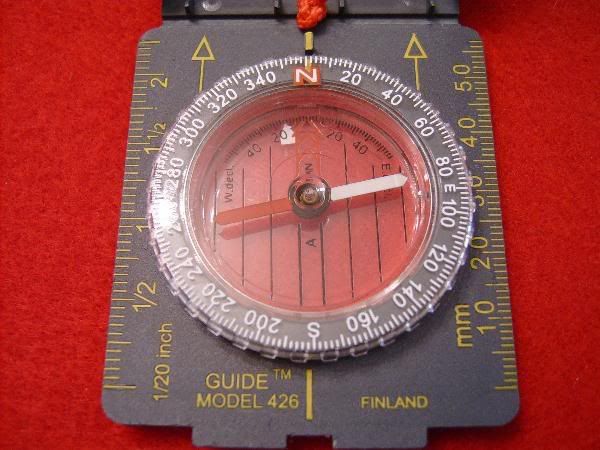
Just remember to place the compass magnetic needle in top of that mark to compensate for the declination.

It will be good if before entering the woods you can count with a base line; the base line could be the road where you left your car, a river, a power line or any other feature that is marked on the map and goes for a long way, that way you always have the option of trying to reach your base line if you are running out of daylight.

USE HANDRAILS IF YOU CAN

A handrail is a feature that is marked on the map. A trail, river, or other geographic feature that goes in the direction you want to go. When you are in a handrail, you are in a line of position. If you know you are on the trail or next to the creek, to find your point position you just need another feature that is on the map from where you can take a compass back bearing in the field.
Let’s say you see a hill in the distance that is also marked on the map. Take a back bearing with your compass to that hill, you know how to do that, you point the compass direction of travel arrow to the hill and rotate the capsule until the SOUTH END of the magnetic needle is “boxed” in the declination arrow.
Yes, for a back bearing use the SOUTH end of the magnetic needle, not the NORTH end.
Read the degrees at the junction of the bezel and line of travel arrow, and plot that in your map.

HOW TO PLOT

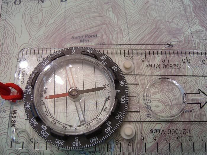
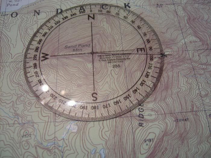
Let’s say that the back bearing you took to the hill is 80 degrees, don’t move the compass capsule to change that reading, place the long edge of the base plate of the compass on the hill that is on the map, and the direction of travel arrow toward your position (the river in this case), make sure the NORTH on the compass is toward the top of the map and then rotate the entire compass (not the capsule) until the North lines scribed in the base plate are parallel with the NORTH lines on the grid of the map.
For map work, always disregard the magnetic needle, you are using your compass as a protractor and measuring angles.
A line traced at the edge of the compass from the hill toward the river, will cross the river at the exact point where you are located, this is your point position. And now you can even read the coordinates of that position from the UTM grid, and tell any rescue party the UTM values of where you are.

TRIANGULATION
This you will have to do when you know only that you are in a general area of your map, your area position.
To get your point position you need two features that are shown in the map from where you can take back bearing in the field. Let’s say you are lucky and you see two hills that are also in the map and at more or less right angles. Take a back bearing on one and plot it in the map, now you are in a line of position, you are somewhere along that line. Take a back bearing on the other hill and plot it in the map, where the two lines cross, there is your point position.
Triangulation works even better when you use three features to take back bearings.

AREA POSITION

If you are in a featureless area with no hills, radio towers, power lines or other help for your triangulation, at least you should have been smart enough to look at your map often and noticed the changes in the topography.
You must know if you passed the hills that are in your map and how long ago, you must know if you are in a flat area and nearing an elevation change in the terrain or if the terrain starts to slope downhill. Based on these clues you will have an idea of what your area position is. With luck the chopper will look for you only in a reduced area of one kilometer based on the coordinates from the UTM grid that you will transmit over the phone or radio.


POINT POSITION AGAIN

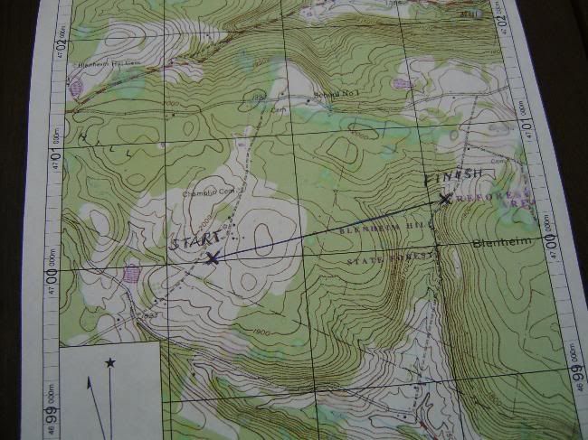
Let’s give here one example of point position using a real map, and a figured scenario so you understand how important point position is even if you are not interested in marking your tree stand on the map.

Let’s say I am exploring the top of B-----g Ridge in the Adirondacks, this is a ridge that encompasses many miles and even knowing I was there, I didn’t know where I was exactly.
To the West I can see the peak of S--d Pont Mountain, one of the tallest in the area.


Presently, I spotted in the forest floor something flashing in the sunshine and in picking that up; I held in my hands a pair of prescription eye glasses.
In further looking around I discovered a human skeleton dressed in the remains of orange hunting clothes. A rusty rifle near by confirmed my assessment that the unfortunate bones belonged to a hunter.
Looking at the back of his jacket remains I found a license tag protected by a transparent license holder, as the tags are made of weather and tear resistant material they have survived quite well the estimate three or four years of exposure to the elements.


In my pack I had some orange surveyor tape and I marked the area with it, then I took out my compass and took a back bearing to the top of S--d Pond Mountain, the back bearing is taken with the SOUTH part of the needle because you want the bearing FROM the mountain to your position. You can also take a direct bearing but then when plotting it in the map the direction of travel arrow should be pointing to the MOUNTAIN instead of from the Mountain to your position.
I like to do the back bearing, because if I were using a regular protractor the numbers to my position will be the back bearing numbers.

The back bearing indicates a 95 degrees direction from the top of the mountain, so I placed the compass with one long edge on the peak of the Mountain, and the direction of travel arrow toward the B----g Ridge, making sure that the NORTH part of the compass points toward the NORTH part of the map.
I rotated the whole compass by the base plate (I don’t touch the capsule or change the setting in the bezel) until the lines inscribed in the base of the capsule are parallel to the North lines on the map.
Now the edge of the base-plate is passing over my exact position on the Ridge. I traced a pen line to connect the two points, and placed an X in the map to mark my discovery.

As I had to be back in New York City next morning for a court hearing, it is no way I was going to be bringing a party here to the top of the ridge, or getting further involved in this matter, so late that afternoon on my way back to New York I dropped an envelope in the police headquarters with a note of explanation, the marked map and the hunting tags of the corpse.
By the UTM grid they can get the exact location in Easterns and Northings and transfer that to a GPS equipped chopper and effectuate the recovery as well, or better, that if I were there to direct them.

All the best

Watchmaker
Back to top
View user's profile
ElyBoy
Super Member
Super Member


Joined: Apr 04, 2006
Posts: 1541
Location: Forest Lake Minnesota

PostPosted: Sun Sep 30, 2007 8:13 pm    Post subject: Re: COMPASSES Reply with quote

Don't take me wrong Watchmaker, but many of the old woodsmen that I knew and taught me how to navigate in the woods, used the same stuff as you do, without getting so complicated.
Most of those guys never got out of Middle School.
Like I say, keep it simple, and you will always get out of the woods.

Remember--- You can ALWAYS point the hour hand of your watch towards the sun. Halfway between the hour hand and twelve o'clock will be due south, UNLESS you live in Australia. Smile

Eric

_________________
NRA Certified Chief Range Safety Officer
NRA Certified Pistol Instructor
DNR Certified Firearms Safety Instructor
NRA Life Member
Back to top
View user's profile
FALPhil
Super Member
Super Member


Joined: Aug 18, 2007
Posts: 377
Location: Dixie

PostPosted: Sun Sep 30, 2007 8:27 pm    Post subject: Re: COMPASSES Reply with quote

I don't know a whole lot about UTM, but it sounds like a European solution to a non-existent problem.

_________________
The Wicked Witch of the West is alive and well and serving as the Speaker of the House.
Back to top
View user's profile Photo Gallery
watchmaker
Member
Member


Joined: Jun 29, 2007
Posts: 98
Location: New York

PostPosted: Fri Oct 05, 2007 8:24 pm    Post subject: Re: COMPASSES Reply with quote

ElyBoy wrote:
Don't take me wrong Watchmaker, but many of the old woodsmen that I knew and taught me how to navigate in the woods, used the same stuff as you do, without getting so complicated.
Most of those guys never got out of Middle School.
Like I say, keep it simple, and you will always get out of the woods.

Remember--- You can ALWAYS point the hour hand of your watch towards the sun. Halfway between the hour hand and twelve o'clock will be due south, UNLESS you live in Australia. Smile

Eric

If the sun is out
Back to top
View user's profile
oldpops
Rookie Member
Rookie Member


Joined: Oct 07, 2007
Posts: 20
Location: Behind the trigger

PostPosted: Mon Oct 15, 2007 8:03 pm    Post subject: Re: COMPASSES Reply with quote

Great thread watchmaker: I've never even come close to getting lost in the woods (some people just have that compass built in). Last time I got lost was at Dallas Fortworth trying to get back to the terminal with the rental car and I even had a GPS aboard. It took me two and a half hours to get back to the terminal to pu the rest of the crew that came in on a later flight. I do better in the woods. So people can get lost in their back yard, so I keep up the great post. The GPS along with Google Earth is the greatest tool for scouting public lands and being able to locate the pinch points and natural pathways right from your desk at home. Two of the best spots I have found lately came from scanning the area in google earth then transfering the coordinates to my gps and walking directly to them. Keep up the good work.
Pops
Back to top
View user's profile
rdncktink
Super Member
Super Member


Joined: Mar 02, 2007
Posts: 476
Location: Hwaseong, South Korea

PostPosted: Mon Oct 15, 2007 11:01 pm    Post subject: Re: COMPASSES Reply with quote

Maps are good for planing. Beyound that I don't trust them. I've followed a guy into the woods with a map and had to "hunt" my way out. As long as there is a sun or moon I'm good. I guess it's that natural compass things. My grandpa always said don't trust people with a compass.

My brother is one of those people who can't find their way home in a town he grew up in. Me on the other hand was dropped at Fallen Leaf Lake when I was about 10 and told to find the truck with my parents in toe. To get down to the lake we spent about an hour on various trails. To get back I decided about where we were and headed for it. I was off by about 50 feet.

_________________
Don't whine how bad your country is until you live in another.
Back to top
View user's profile AIM Address Yahoo Messenger
Vince
Site Admin
Site Admin


Joined: May 25, 2005
Posts: 15713
Location: Brisbane AUSTRALIA

PostPosted: Mon Oct 15, 2007 11:40 pm    Post subject: Re: COMPASSES Reply with quote

rdncktink wrote:
Maps are good for planing. Beyound that I don't trust them. I've followed a guy into the woods with a map and had to "hunt" my way out.

A professionally made Topographical map is good. When a cartographer is putting a map together he uses every resource available to him, satellite pics, aerial photos and the Mk 1 Eyeball, to ensure the accuracy of the map.....this includes walking areas that he feels necessary. The other thing about a topo map is that you have the date of production and other pertinent info in the border of the map that tells you pretty much everything you need to know....including the magnetic variation.

A map doesn't lie, and assuming that you have looked after your compass, it won't either. All you need to know is how to use them both....and practice it. Sounds like the guy you followed didn't know how to use either correctly.

Cheers, Vince


edit 3.jpg
 Description:
 Filesize:  170.7 KB
 Viewed:  6266 Time(s)

edit 3.jpg


_________________
Cheers, Vince Cheers

Illegitimi non carborundum
(Never let the bastards grind you down)

Live simply. Love generously. Care deeply. Speak kindly. Leave the rest to God.

"Nulla Si Fa Senza Volonta."
(Without Commitment, Nothing Gets Done)
Back to top
View user's profile AIM Address MSN Messenger Yahoo Messenger Photo Gallery
rdncktink
Super Member
Super Member


Joined: Mar 02, 2007
Posts: 476
Location: Hwaseong, South Korea

PostPosted: Tue Oct 16, 2007 12:06 am    Post subject: Re: COMPASSES Reply with quote

The guy said he was good at it. I think that what the problem was, was that he didn't take into account that the lake was about 10 feet lower than normal and he was still following the lake like the map said.
Now I've been trained on how to follow a map and use a compass. And I'm okay at it, but I still trust myself more than compass. I do use a map and follow land marks more.

_________________
Don't whine how bad your country is until you live in another.
Back to top
View user's profile AIM Address Yahoo Messenger
Vince
Site Admin
Site Admin


Joined: May 25, 2005
Posts: 15713
Location: Brisbane AUSTRALIA

PostPosted: Tue Oct 16, 2007 12:11 am    Post subject: Re: COMPASSES Reply with quote

Nothing wrong with doing "Map to Ground" navigating, so long as you are totally certain where you are to start off with and you also know your map, its symbols, what you are doing and measure your distances walked accurately.

Like you I prefer Map to Ground, but I always carry a compass and check it regularly and I count paces where necessary. Also, my bounds are realistic in length and I do a nav check everytime I change direction.

Cheers, Vince

_________________
Cheers, Vince Cheers

Illegitimi non carborundum
(Never let the bastards grind you down)

Live simply. Love generously. Care deeply. Speak kindly. Leave the rest to God.

"Nulla Si Fa Senza Volonta."
(Without Commitment, Nothing Gets Done)
Back to top
View user's profile AIM Address MSN Messenger Yahoo Messenger Photo Gallery
Dimitri
Super Member
Super Member


Joined: Nov 25, 2005
Posts: 5944

PostPosted: Tue Oct 16, 2007 4:18 pm    Post subject: Re: COMPASSES Reply with quote

I know many people that claim can read a topo map and use a compass. Many of them can't even use a road map in my experience though. Laughing

I ordered 2 days ago along with a pack/frame and a few other camping/hunting items one of these for the heck of it:


Quote::
MAPTOOLS SUPER GTAâ„¢
MGRS/UTM COORDINATE GRID READER" & "PROTRACTOR
The SUPER GTA is an improved version of the military Graphic Training Aid 5-2-12 Coordinate Scale and Protractor used by United States and NATO military forces around the world. By using a slot on one side of the tool for access to the map, the tool can be more compact than the traditional GTA tool. The tool features several additional map scales, including 1:24,000, which is the most common topographic map scale found within the United States. The 1:100,000 scale now spans 5km grid lines, making it much more usable. Plus, the overall dimensions is the size of a CD, easially fitting into a pocket. The inner protractor is marked in degrees and the outer protractor is in mils.

Never used one before but saw them refered to in a few military manuals so I decided to pick one up. Smile

Dimitri

_________________
A thousand hills, but no birds in flight, ten thousand paths, with no people's tracks. A lonely boat, a straw-hatted old man, fishing alone in the cold river snow.
Back to top
View user's profile Photo Gallery
ElyBoy
Super Member
Super Member


Joined: Apr 04, 2006
Posts: 1541
Location: Forest Lake Minnesota

PostPosted: Tue Oct 16, 2007 7:02 pm    Post subject: Re: COMPASSES Reply with quote

Is it me, or is everybody getting too complicated around here??? wtf wtf wtf
I should start a new post on what finger a guy should use to wipe his rear end.
I'll bet all of the rocket scientists will come out of the woodwork on THAT one. Pictures and all. Very Happy


Eric Confused Confused wtf wtf wtf Confused

_________________
NRA Certified Chief Range Safety Officer
NRA Certified Pistol Instructor
DNR Certified Firearms Safety Instructor
NRA Life Member
Back to top
View user's profile
tikkat3
Super Member
Super Member


Joined: Jul 30, 2006
Posts: 800

PostPosted: Wed Oct 17, 2007 12:49 am    Post subject: Re: COMPASSES Reply with quote

Great pictures 'Watchmaker', unfortunately to many words to read.
My GPS works best in the 'Vibrate' mode.
Back to top
View user's profile
Display posts from previous:   
Post new topic   Reply to topic   Printer Friendly Page    Forum Index » Big Game Hunting
Page 3 of 6
All times are GMT - 7 Hours
Go to page Previous  1, 2, 3, 4, 5, 6  Next


Jump to:  


You cannot post new topics in this forum
You cannot reply to topics in this forum
You cannot edit your posts in this forum
You cannot delete your posts in this forum
You cannot vote in polls in this forum
You cannot attach files in this forum
You can download files in this forum


Valid CSS! Valid HTML 4.01!
Click to check if this page is realy HTML 4.01 compliant for speed :)

All logos and trademarks in this site are property of HuntingNut.com.
The comments are property of their posters, all the rest © 2011 by HuntingNut.com
Interactive software released under GNU GPL, Code Credits, Privacy Policy

.: Upgraded to DragonFly 9.2 by *Dizfunkshunal* :.