 I couldnt pass it up for the price.
| PaulS wrote: |
| A compass is worthless unless you use it from the start of your trip. |
| shrpshtrjoe wrote: |
| I recently bought one from a guy at work a Lowrance I Finder Hunt. It seems to be a decent one there was no paperwork with it I can get the instructions online I just haven't got around to it I couldnt pass it up for the price. Joe |
| glockman55 wrote: |
| Here where I live there is a road a mile away in any direction. |
| PaulS wrote: |
| A compass is worthless unless you use it from the start of your trip. If you walk away from camp for two hours and then decide you are lost and try to find your way back with a compass you are going to be more lost. My brother and I used to practice getting to some place with a view, pulling out our map and compass and trying to locate where we were on the map. It is pretty easy when you are in the mountains but out on the flats of a desert it gets problematic. You have to find streams, lakes, small hills and just about anything that shows on the map that you can see to locate your position. I assumed everyone did that... we were never taught - it was just something we needed to know....in case. |
| Vince wrote: |
Its called doing a Re-section. Not the easiest thing to do, but if I can do it, then pretty much anybody can. All you need is a compass, map and protractor. Identify three or more points on the map that correspond with the ground then starts shooting some bearings. Convert your bearing to a back bearing, plot it on the map and you will end up with a "triangle of error". This triangle may be as much as 100 yds sq, but you are inside it...on the ground. |
| gelandangan wrote: |
| could you do a small write up of this technique? |
| Quote:: |
| 6-8. RESECTION Resection is the method of locating one's position on a map by determining the grid azimuth to at least two well-defined locations that can be pinpointed on the map. For greater accuracy, the desired method of resection would be to use three or more well-defined locations. a. When using the map and compass method (Figure 6-18)— (1) Orient the map using the compass. (2) Identify two or three known distant locations on the ground and mark them on the map. (3) Measure the magnetic azimuth to one of the known positions from your location using a compass. (4) Convert the magnetic azimuth to a grid azimuth. (5) Convert the grid azimuth to a back azimuth. Using a protractor, draw a line for the back azimuth on the map from the known position back toward your unknown position. (6) Repeat 3, 4, and 5 for a second position and a third position, if desired. (7) The intersection of the lines is your location. Determine the grid coordinates to the desired accuracy. a. When using the straightedge method (Figure 6-19)— (1) Orient the map on a flat surface by the terrain association method. (2) Locate at least two known distant locations or prominent features on the ground and mark them on the map. (3) Lay a straightedge on the map using a known position as a pivot point. Rotate the straightedge until the known position on the map is aligned with the known position on the ground. (4) Draw a line along the straightedge away from the known position on the ground toward your position. (5) Repeat 3 and 4 using a second known position. (6) The intersection of the lines on the map is your location. Determine the grid coordinates to the desired accuracy. 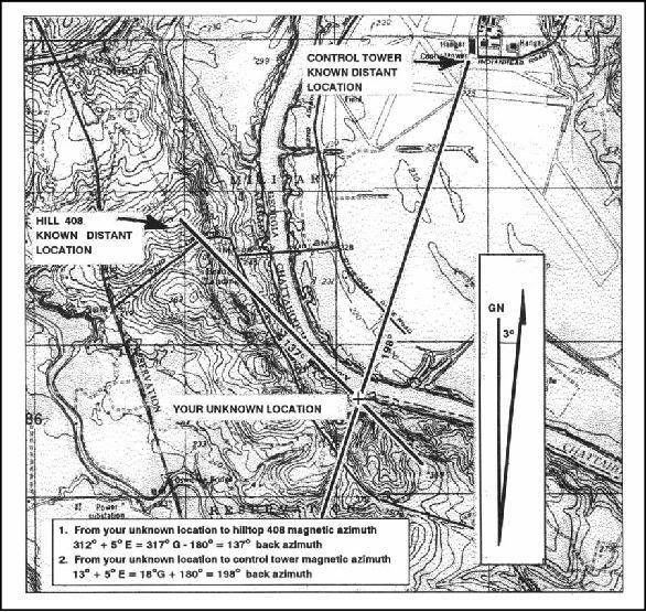 |
| Quote:: |
| a. When using the straightedge method (Figure 6-19)— (1) Orient the map on a flat surface by the terrain association method. (2) Locate at least two known distant locations or prominent features on the ground and mark them on the map. (3) Lay a straightedge on the map using a known position as a pivot point. Rotate the straightedge until the known position on the map is aligned with the known position on the ground. (4) Draw a line along the straightedge away from the known position on the ground toward your position. (5) Repeat 3 and 4 using a second known position. (6) The intersection of the lines on the map is your location. Determine the grid coordinates to the desired accuracy. 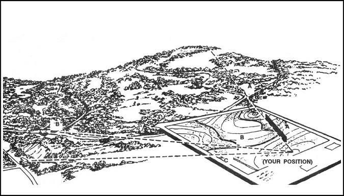 |
All times are GMT - 7 Hours